Sunday, January 12, 2020

Why climate models disagree on Earth's worst-case scenarios | Science News

Scientists still aren’t sure what the worst-case scenario for Earth’s future climate looks like

Earth’s climatic future is uncertain, but the world needs to prepare for change.
Enter climate simulations, which re-create the physical interactions between land, sea and sky using well-known physical laws and equations. Such models can look into the past and reconstruct ancient ice ages or hothouse worlds with the help of data gleaned from rocks and ice cores.
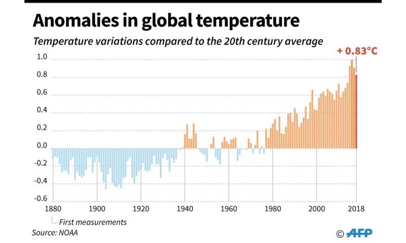
Image result for French climate models consistently predict a pronounced global warming"

But climate scientists also use these simulations to envision a range of different possible futures, particularly in response to climate-altering greenhouse gas emissions. These Choose Your Own Adventure–type scenarios aim to predict what’s to come as a result of different emissions levels over the next few decades. That means putting upper and lower boundaries on answers to questions such as: How hot will it get? How high will the seas rise?


Continue reading at: Why climate models disagree on Earth's worst-case scenarios | Science News

Mapping the Coal Ash Contamination | Earthjustice

Do you live near a coal plant? The Environmental Protection Agency is proposing to allow companies to delay closing unlined, hazardous coal ash ponds.

President Trump's attempt to weaken coal ash pollution safeguards is nothing more than a total giveaway to the coal industry and must be rejected.

Tell the EPA to reject this harmful rollback.

The Ligurian Bees of Kangaroo Island - Features Journal - Native Food and Wine

The Ligurian Bees of Kangaroo Island - Features Journal - Native Food and Wine

Thursday, January 9, 2020

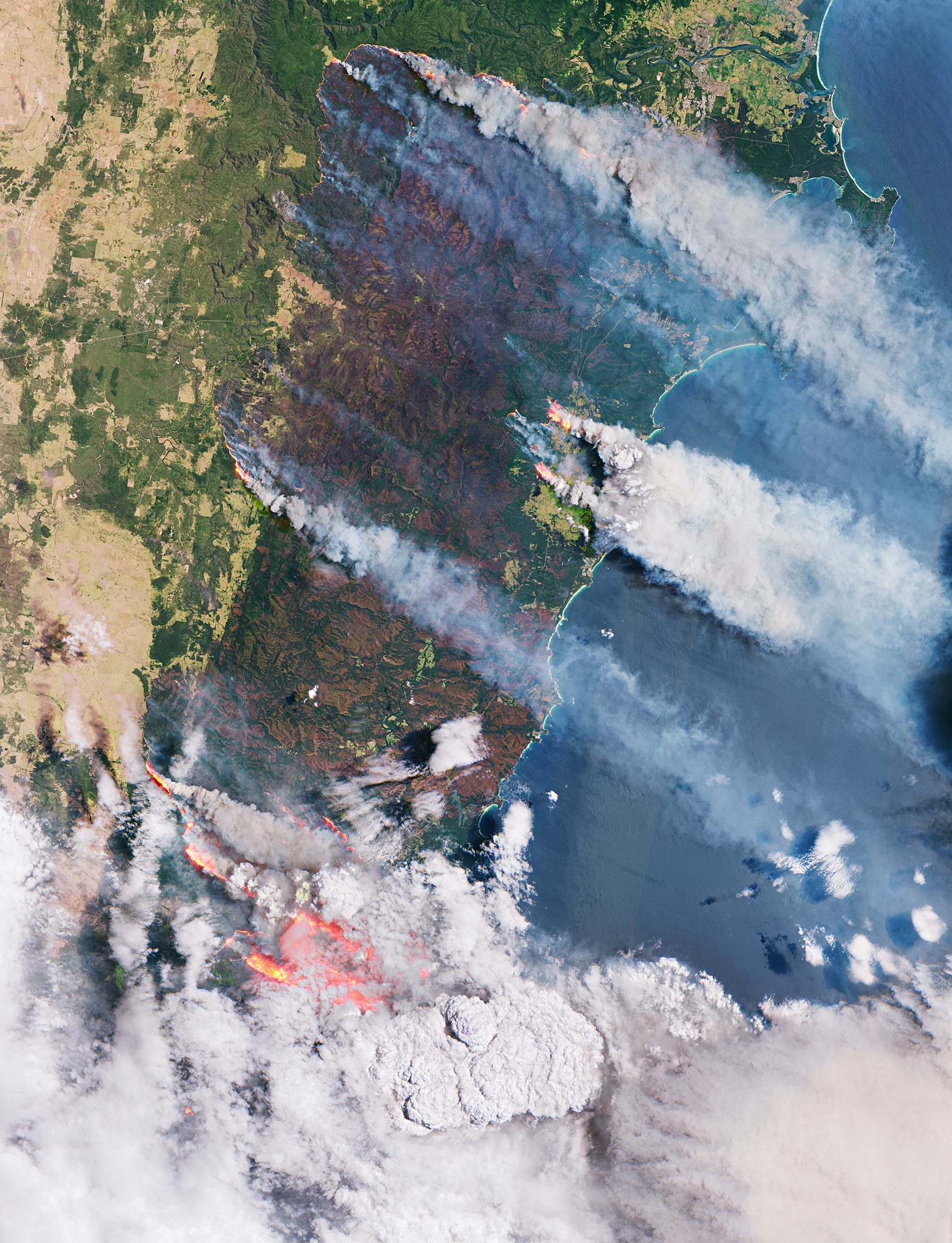
Australia: Like a Furnace – Incredible Satellite Images Reveal Ferocious Bushfires

More trees lost means faster into the climate catastrophe, more human misery, more wildlife suffering and death, more and faster loss of biodiversity and more of this planet's beauty gone - and who is to blame for all of this?


THE COPERNICUS SENTINEL-2 MISSION HAS BEEN USED TO IMAGE THE FIRES. THE SENTINEL-2 SATELLITES EACH CARRY JUST ONE INSTRUMENT – A HIGH-RESOLUTION MULTISPECTRAL IMAGER WITH 13 SPECTRAL BANDS. THE SMOKE, FLAMES AND BURN SCARS CAN BE SEEN CLEARLY IN THE IMAGE SHOWN HERE, WHICH WAS CAPTURED ON 31 DECEMBER 2019. THE LARGE BROWNISH AREAS DEPICT BURNED VEGETATION AND PROVIDE AN IDEA OF THE SIZE OF THE AREA AFFECTED BY THE FIRES HERE – THE BROWN ‘STRIP’ RUNNING THROUGH THE IMAGE HAS A WIDTH OF APPROXIMATELY 50 KM AND STRETCHES FOR AT LEAST 100 KM ALONG THE AUSTRALIAN EAST COAST. CREDIT: CONTAINS MODIFIED COPERNICUS SENTINEL DATA (2019), PROCESSED BY ESA, CC BY-SA 3.0 IGO


Continue reading at: Australia: Like a Furnace – Incredible Satellite Images Reveal Ferocious Bushfires

Michigan PFAS Drinking Water Standard

Please consider posting a citizen comment to demand that everything is done to protect our water from these dangerous pollutants!


Michigan PFAS Drinking Water Standard