Showing posts with label Michigan DEQ. Show all posts

Saturday, August 3, 2013

Savoy's Oil Production in our Area

I tried to pull the public data on well production on the DEQ website at http://www.michigan.gov/deq/0,1607,7-135-3311_4111_4231-98518--,00.html but it is not as easy as you would think. Data are stored as PRU (Production Reporting Unit) and have to be aligned to the well permit number, which could be easier, and is not always a 1:1 relationship, meaning a PRU can include several wells - and there is no convenient way to export the more than 2 months old data from the Online Data Base at http://ww2.deq.state.mi.us/mir/ so I had to write the numbers down. There is also a Microsoft Access data base that you can download but it is even more behind (lacks data for April and March 2013!). I finally managed to get these numbers:

First, Savoy is the 3rd largest exploiter of crude oil in Michigan at a 2013 total of 236606 barrels. The largest player is West Bay Explorations, which exploit the oil fields in the Irish Hills at 811494 barrels in 2013. Number 2 is Merit Energy at 457779 barrels. These numbers are from March 2013 though!

The below table is a small selection of the total oil production in our area. I just pulled the two wells closest to the City of Adrian and two wells more NW in Adrian township, and SE in Palmyra township. However, some wells in these areas are producing more, others less than the figures shown. The two selected locations are in no way representative for their areas.


Date Production in barrels

Heritage Park Witt Farm 60488 in Palmyra 60558 Pentecost Hwy
Feb-13 - 1697 150 2773
Mar-13 - 5628 108 4602
Apr-13 160 6162 101 3789
May-13 620 6050 91 3391


The oil companies have 45 days from the end of a month to report (yes, you heard right - they monitor how much they make themselves - there is no calibrated device that measures production) - then the overworked and understaffed DEQ has to compile and update the database - resulting in a time lag of currently more than 2 months. Therefore we do not have data on any newer wells yet - or more recent changes in production of present wells. Therefore there are no data yet on the wells on the Purse Funeral Home, Stratton's Landscaping, or the 1-3 wells off Carson Highway.


Friday, July 26, 2013

The Extend of Oil and Gas Drilling in Michigan

Unbelievable - if you project all oil and gas well records (including dry holes) onto a map of Michigan - almost no place in the lower peninsula is really 100% untouched, clean, and pristine. Where is PURE MICHIGAN?


Thursday, June 13, 2013

Friday, May 24, 2013

Response to the DT article: Health Department leaving oil regulation toDEQ

While I appreciate any news keeping the public aware of this topic, this article contained factual and implied misinformation that I will address with this response. A copy of this blog post will go to Patricia Bourgeois, Lenawee county health officer, Lou Schineman and Kristy Shimko, Michigan DEQ, and the Adrian city commissioners with the request to comment.

1. I do not think that the county's (or the city's) responsibility ends because a higher entity is watching upon us. If these authorities are not protecting our health and the integrity of air and water as essential resources adequately, then the county's health department(, and the city) are obliged to step in! I will provide good arguments that exactly that is needed.

2. The DEQ is NOT monitoring surface water, ground water or air quality near drilling or processing facilities. There are no baseline tests nor any follow-up tests done that could show changes through the activities of that industry. The burden of proof is once more on citizens to arrange for such tests and to do so - restricting them to only certain certified and very expensive test labs - and requiring commercial lab staff to take the samples - thus even raising costs further - which in the end leads to not many citizens being able to test their - our vital resources.

3. Most site visits and checkups (which do NOT include actual sampling!) are done by the oil and gas companies themselves. The DEQ is understaffed and instead of raising permit fees to have enough money to adequately monitor the activities of oil and gas drilling and processing, it is simply assumed that the oil and gas companies are honest and doing a good objective job in self-monitoring themselves. This is more than wishful thinking as corporations are by law required to maximize shareholder profit even at the cost of externalizing (environmental) costs - meaning having somebody else (often the government) pay the bill.

4. Lou Schineman, district manager of the DEQ’s Office of Oil, Gas and Minerals - or the staff writer Dennis Pelham, or an anonymous editor is wrong (does not know better or is misleading) when they state: "The gas being burned is basically the same as what is piped into businesses and homes and burned in furnaces, stoves, clothes dryers and water heaters". Several publications analyzing flare gases and volatiles found high concentration of toxic and cancerous BTEXs (benzene, toluene, ethylbenzene, and xylenes) and other compounds in flare gases. They partially originate from the oil and gas deposits themselves and come up in the extraction process, or are in drilling aid chemicals or site treatment chemicals. I am more than happy to produce a full list of publications and chemicals upon request. Most of these dangerous chemicals are NOT in the natural gas that we use in our houses - the gas companies are required to take these dangerous chemicals out before delivering the natural gas to the customers.

5. Kristy Shimko - or the staff writer Dennis Pelham, or an anonymous editor are wrong when they say that "the flares are burning methane and nitrogen". Methane yes (about 65% of the flammable composition), but nitrogen does not burn and is as such not flared off. While it is great that the DEQ monitors for hydrogen sulfide, that should not be the only thing they do (see above)!

6. Why is the industry permitted to flare off and WASTE a potential energy resource while POLLUTING the air for SO LONG (more than 6 months)? They should NOT be able to acquire permits to start drilling before they have the infrastructure to collect and market the gases in place!

7. If flares are located on the country-side with maybe one farmhouse close to the flare (I am idealizing here - in the Irish Hills it is often many houses, and unfortunately not only owned by the profiteer of the royalties), it is an entirely different situation within the city of Adrian with quite a few residences around the flare on Witt Farm.

8. In addition to the danger to air and water by the drilling operations and the processing facilities (tank farms), the highest chances of oil and gas spills occur during loading and unloading (e.g. into trucks) as well as during transportation (by pipelines and trucks). Both areas are to my knowledge not regulated by the DEQ - and therefore the county health department cannot depend on the DEQ to safeguard health in these error-prone sectors of the oil and gas business. Looking on the shortcomings of DOT regulations for pipelines (remember the 2010 pipeline accident near Kalamazoo, Michigan?) and trucks (several accidents involving oil trucks every year) - the nearly operational pipeline from Heritage Park (and soon other surrounding drill sites) to the Witt Farm cutting through the River Raisin floodplain, and the increased truck traffic that the central facility on Witt Farm will bring to the city once more wells are connected, the county health department (and the City of Adrian) obviously have to get and stay involved to safeguard the health of our citizens!

Tuesday, May 21, 2013

Drilling of Pipeline under Beaver Creek Continues - New Drilling Site on Property of Stratton's Landscaping


After postponing the operations due to a soccer tournament (how nice of Savoy!), they continued to work on the pipeline today - and they started drilling for oil on the property of Stratton's Landscaping - as previously suspected by Victoria.


Large Drilling Derrick on Stratton's. Location of Site on Map Below.

 Today's investigational journalism got us a home visit of the state police. Savoy had the driveway down to the disc golf area blocked off. However, nobody stopped us from walking down there.


I approached the new construction site at the end of the buried pipes down at the disc golf area - and was approached by a nice young man from the construction company to whom I talked before. He told me that I should not approach the construction site any closer, which I respected. The reasons given were liability issues. I took some more pictures, Amy and I talked a little more with the guy, who threw sticks for our dog. On our way back to the car, I was approached by a gray-haired - casually dressed guy, who I have seen around the Heritage drilling site before. (Edit: Jack Rokos is Savoy's Operations Manager). He told me he was from the oil company and ordered me quite aggressively to stay away from "his" construction site and I assured him that we will do so - and that we obeyed before and did not approach the site closer than about 100-200 yards. By the way, there were also disc golfers down there that were not approached by the oil and construction staff - and were not any further away...I wonder why we get a special treatment???  


I tried to get some more information about the final drilling process to connect the pipelines and after confirming that drilling was done vertically and horizontally from up off Howell Highway and would reach exactly to the end of the buried pipes at the disc golf area, and that no clearing of the woods towards Beaver Creek would be necessary, he changed his mind and would not give out any other useful information. We assured him that we would stay away from the actual construction site and started walking down a beautiful, lush green path, that was heading towards the drilling noise from the new drilling site on Stratton's. The path did not really get us closer to make any pictures from public land and ended soon at a pretty deteriorated fence to private property, which we - as it is our principle - did not enter. During this walk in the woods we heart 2 bangs that sounded like small gas explosions (between 2 and 2:15 pm). In the favor of believing in the good of people, I was thinking that that's why we were asked to stay at a safe distance...


 We went back to the car to see that now 3 cars were blocking the driveway down to the disc golf and model plane area. We drove away and wanted to see if we could get a better shot of the drilling rig on Stratton's from the Skating compound, when we realized that one of the three cars was following us. We did a loop around the old farm building on Heritage and went behind the truck that probably was send to follow us? 


  We went across the street to the skating ring and I took a few pictures of the rig (see above), when we realized a state police car pulling into Heritage Park - sure enough - we soon had two friendly officers in our apartment hallway at home - that wanted to follow up with us what was going on - while assuring us that no complaints were filed. They stated that Savoy leased the City Parks and would therefore have the right to limit - or completely forbid access to a public park during its operations - or for a prolonged time. They also warned us that our friendly dog could get into trouble when approaching workers - which was surely not a problem with today's worker, who threw Faith's stick for her.

All-in-all I do not know what I should make out of this day's occurrences. I do certainly not believe that a lessee of mineral rights is authorized to shut down a public park - not even forbid access to areas beyond the immediate work area. As I stated before, I do not trespass on private property, especially if it is clearly marked as such - and I respected the "orders" of the worker and the oil company guy to stay at a save distance from the construction site, without the site being properly marked as such, or a clear statement in any ordinance stating to stay lets say 200 yards away from oil and gas operations...
I cannot shake the feeling off that Savoy - and a few beneficiaries of the oil boom in our city - are getting irritated and start to harass me and the investigational journalism that I try to develop. It began with the city police being called in when I showed a team of the Toledo Blade around. Again, we stayed off of clearly marked or obvious private properties - and no closeup pictures of persons were taken - beside mine, which I was OK with. I actually just received a harassing phone call of somebody, who obviously profits from the oil hysteria in Adrian - and did not like the pretty mallow article in the Toledo Blade...

If my humble careful writing and pictures are causing such inappropriate response - then there is maybe a reason why people get nervous - there is maybe really something they want to hide - and not bring to public notice?
Luckily, what I am doing is not depending on me alone and there are more people involved in this matter than can be easily threatened and silenced!


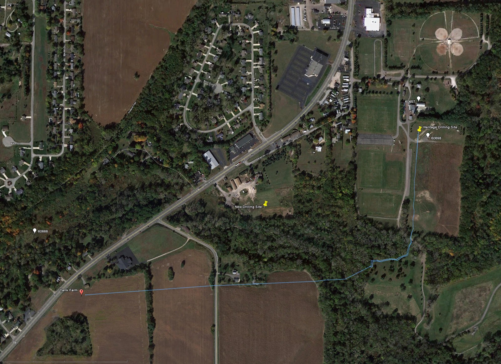
Location of the new drilling operation. I hope the pipeline from that well will not also cross Beaver Creek to reach Witt Farm

Current wells around Witt Farm - check them out on your own at:

Thursday, May 16, 2013

Michigan - Lenawee County - Adrian Wells

This map is now a little older but still good:
Well Locations of Savoy Oil in Michigan

Tracking Oil and Gas Wells


Resources and Links (Shared by Pam Taylor)
To track the wells:
 
To see the wells in Lenawee County, use the MIDEQ map below. This map is updated monthly.  First, use this map to find the well number. You might want to magnify the map to 200% or so, using the control at the top to make it easier to see the numbers and to read the key. The key on the right explains everything. This map is updated monthly, and it’s a pretty quick way to see the most current status. Class II brine disposal injection wells have a blue triangle around their circle. (These are the ones that may be associated with earthquakes, according to a recent USGS Report.) You don't necessarily need to have "fracked" wells (although some would say that all wells are "fracked" to some extent) in order to use injection to dispose of the waste fluids. Often Class II brine disposal wells are located at tank farms.

http://www.dnr.state.mi.us/spatialdatalibrary/pdf_maps/mineral_lease_information/lenawee_lease_information.pdf

Once you know the number, you can look up more data here. (You might have to adjust your Java settings; this might work easier with Google Chrome than Internet Explorer, if you have a choice of browsers.)

http://ww2.deq.state.mi.us/mir/

Click on "Well Data Search", then "Well Information", then all you have to do is type in the well number that you took from your map. If nothing comes up when you type in a number, it probably means that the driller has requested confidentiality and that it won't be listed until the confidentiality period has expired. You can still see the location of the wells on the map (above link), which is the reason for the suggestion to use the map first. This database isn't as current.

Current Class II brine disposal injection wells are on Knight Hwy. in Adrian Township and along U. S. 223 in Palmyra Twp.; a new one just was permitted on Shepherd Rd. also in Adrian Twp. These are the type of wells that, according to the USGS, have not been ruled out as contributory factors in earthquakes in Ohio and the Midwest.  Waste, including fracking fluid and/or flowback, from the drilling process, and from processing the extracted oil, is pressure-injected deep into the earth.  These wells are:

  • Savoy Energy, McMunn Farms, Palmyra Township, No. 60531 (This well is between U. S. 223 and Carleton Rd., just south of where Humphrey Hwy. dead ends on U. S. 223.)

  • Savoy Energy, 60152, Ruesink, Adrian Township, No. 60152 (This well is on Knight Hwy., between Emery and Moore Rds.)

  • The third well is EPA permit request MI-091-2D-0003, Goetz property off of Shepherd Rd., Adrian Twp., dated June 27, 2012.  Well No. unknown at this point.  This injection well is in the oil field off Shepherd Rd. (just look for the 24/7 flare), about three miles north of Adrian.


To get information about Class II underground injection wells planned:

EPA well permit public notice and comment period information:


EPA contact number to get on the Class II injection well notification list so you can request a public hearing (they won't hold a public hearing unless a member of the public requests one, and you won't know that an injection well is planned unless you're on the list): Call the Region 5 EPA Office at 800-621-8431, press "0" at the prompt, the operator will put you through to someone who will put you on the list. Public hearings are important for media attention, and to inform the public and politicians so they can make appropriate decisions, more than they are effective in getting these things stopped.

To find updated permits:

You can find the weekly permit applications/permits issued/dispositions for all wells (not just injection wells) at the link below. Not as quick as the first two links, but once you start checking them, it's pretty easy to keep up to date.

http://www.michigan.gov/deq/0,4561,7-135-3311_4111_4231-121842--,00.html


To see where fracked wells in the area are located:

Map of fracked wells in the vicinity (North Adams and Wheatland Twps. in Hillsdale County)

http://www.michigan.gov/documents/deq/utica-_collingwood_activity_map3_354847_7.pdf

List of these fracked wells:

http://www.michigan.gov/documents/deq/utica.collingwood_spreadsheet1_358438_7.pdf

Putting it all together:

In some parts of Lenawee County, these wells are located in the same places where CAFOs impact the environment.  The overlap with the CAFO areas all starts with the county drain system and the waterways. If spills/leaks occur, this will first become apparent. Many of these wells run right on top of county drains (some of which are underground), and the pipelines are laid along the banks of ditches and streams.  For instance, the wells on Tipton Hwy. that are just across Hunt Rd. from the Adrian Township hall are on top of the Turner Drain.

Here is the Lenawee County Drain map. Click on the township, then magnify. Natural waterways, i.e., Wolf Creek, the River Raisin, Lake Adrian, do not appear on this map unless they are part of the maintained drain system, so you will have to overlay these with watershed maps to see the big picture.

http://www.lenaweedrain.com/images/DrainMaint/DrainMapSelect.htm
 
Leases extend all the way to the state line, running on a southeast diagonal from Napoleon in Jackson County through Riga Township at the opposite corner of the County.


Resources for help in water monitoring/testing programs, and help setting up a group:

Sierra Club Michigan Chapter


It is up to the states to regulate and monitor these wastes.  This page also has an excellent link about testing near sites,  Click on “How We Test Water Around Fracking Sites”


Environmentally Concerned Citizens of Southeast Michigan (ECCSCM) – similar issue; different content


CAFO = Confined Animal Feeding Operation.  Permits administered by the MIDEQ, under the U. S. EPA and the Clean Water Act.  All CAFOs, and all operations that have had a discharge to the waters of the state that caused those waters to not meet water quality standards, must have an NPDES permit to discharge, along with a CNMP (comprehensive nutrient management plan.

Manure scale:  1 cow = 20 people.  We have around 20,000 cows located in this area.  That’s equivalent to the untreated waste of 400,000 people.  For instance, a single, local, CAFO with a permit allowance of 2,500 cows would produce manure equivalent to the waste of about 50,000 people.  As of 2010, Lenawee County had about 99,000 people.

Oil & Gas Pre-Drill Water Well Testing

http://www.michigan.gov/documents/deq/EQP_6553_Homeowner_Water_Sampling_Information_399756_7.pdf