Following what goes on with oil and gas exploitation in and around Adrian, Michigan since 2013 - and how these events in our little city connect to the global environmental situation... - with the occasional sidetrack to other related environmental issues in Lenawee county, Michigan and how those relate to global issues.
Sunday, January 12, 2020
Friday, January 10, 2020
Thursday, January 9, 2020
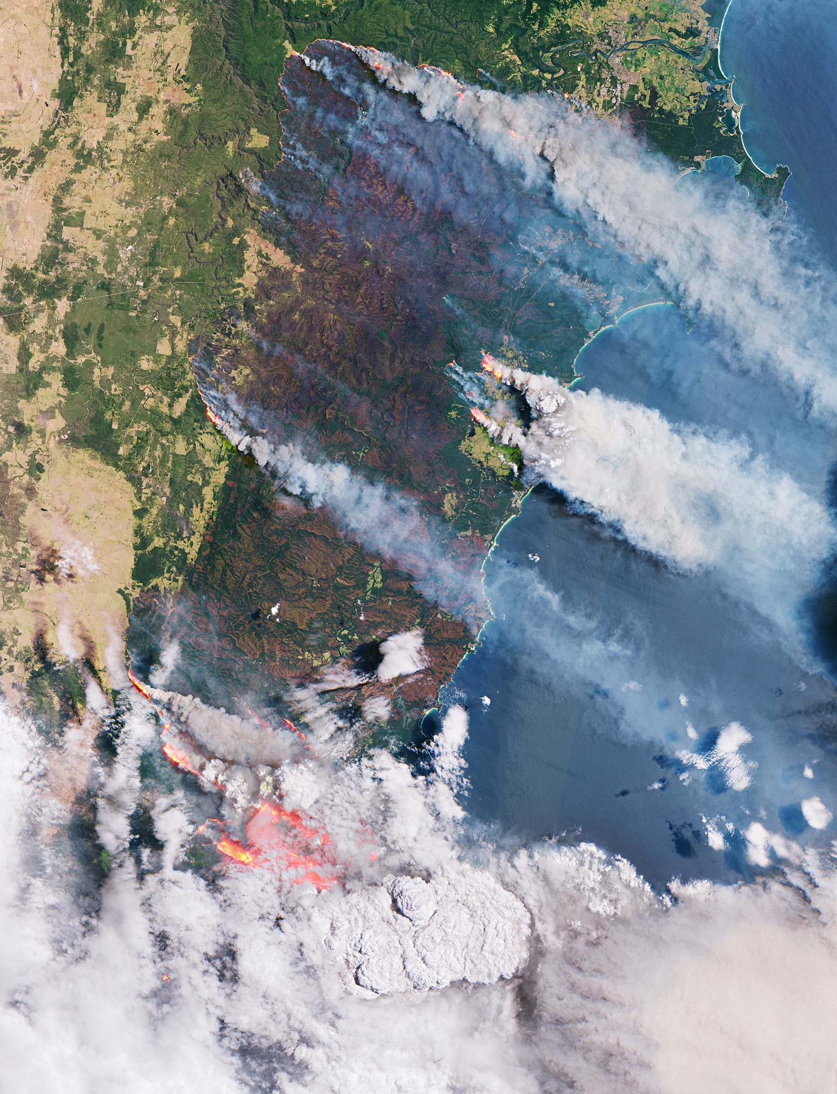
Australia: Like a Furnace – Incredible Satellite Images Reveal Ferocious Bushfires
More trees lost means faster into the climate catastrophe, more human misery, more wildlife suffering and death, more and faster loss of biodiversity and more of this planet's beauty gone - and who is to blame for all of this?

THE COPERNICUS SENTINEL-2 MISSION HAS BEEN USED TO IMAGE THE FIRES. THE SENTINEL-2 SATELLITES EACH CARRY JUST ONE INSTRUMENT – A HIGH-RESOLUTION MULTISPECTRAL IMAGER WITH 13 SPECTRAL BANDS. THE SMOKE, FLAMES AND BURN SCARS CAN BE SEEN CLEARLY IN THE IMAGE SHOWN HERE, WHICH WAS CAPTURED ON 31 DECEMBER 2019. THE LARGE BROWNISH AREAS DEPICT BURNED VEGETATION AND PROVIDE AN IDEA OF THE SIZE OF THE AREA AFFECTED BY THE FIRES HERE – THE BROWN ‘STRIP’ RUNNING THROUGH THE IMAGE HAS A WIDTH OF APPROXIMATELY 50 KM AND STRETCHES FOR AT LEAST 100 KM ALONG THE AUSTRALIAN EAST COAST. CREDIT: CONTAINS MODIFIED COPERNICUS SENTINEL DATA (2019), PROCESSED BY ESA, CC BY-SA 3.0 IGO
Continue reading at: Australia: Like a Furnace – Incredible Satellite Images Reveal Ferocious Bushfires
Michigan PFAS Drinking Water Standard
Please consider posting a citizen comment to demand that everything is done to protect our water from these dangerous pollutants!
Michigan PFAS Drinking Water Standard
Tuesday, January 7, 2020
A World on Fire II
Here is the 2nd part:
Look at the current maps at: https://firms.modaps.eosdis.nasa.gov/map/#z:3;c:-55.1,-0.1;d:2020-01-07..2020-01-08
Much of the tropics and south are burning
Looks like Australia is not the only place burning. I wonder how much forests we loose every day when we should plant a trillion trees or more to turn around the climate crisis. Does anyone really believe what is at stake here?
Look at the fire maps at: FIRMS - Fire Map
Look at the fire maps at: FIRMS - Fire Map
Subscribe to:
Posts (Atom)


