Friday, May 10, 2013

Concerns City Of Adrian & Adrian Township Residents Should Have About Oil and Gas Production Facilities In Your Area!


1.     What is going to be the processing capacity of the plant?
2.      What are they processing (crude, natural gas?) and into what?
3.      How do they plan to provide secondary containment for the facility? (Earthen (Clay)? with High density polyethlyene (HDPE) liners, geotextile liners?, concrete?)
4.      How are they going to dispose of produced water and other wastes?
5.      How are they going to recycle used oil?
6.      What type of air permit will be required? Will it be title V (title V means it pollutes a lot)
7.      What is going to be the storage capacity for oil at the facility?
8.      Who is doing the NEPA study on the environmental impacts from the plant and the pipeline and gathering pipelines associated?
9.      Another concern is what is the potential for increased 18 wheeler traffic in the area and
the safety involved with that?
10.  What are the potential chemicals they will be using at the facility?
11. How equipped is the LEPC in the area (Local Emergency Planning Committee) to respond to an emergency?
12. And who will take on the cost of upgrading fire and hazmat services the community will need from this facility?
13. How much Noise, Vibration and Odor will this facility produce and what will this do to our property values?
14.  What is the potential life span of this facility? 25 to 30 years?
15. How will the City of Adrian spend the proceeds from this operation and will they post the revenue on the city web site with transparency?

Handout shared at the 4/1/2013 city commission assembly by an anonymous citizen with great knowledge of the industry.

Thursday, May 9, 2013

Pipeline Now Also Buried on the Floodplain

Unfortunately, I was wrong - seems to be no problem to submerge the pipes totally under water. Note the dark, almost black swamp muck indicating that the soil is soaked with water for a substantial part of the year.

 Now only the 10 pipes to go through the woods, under Beaver Creek and up the bluff are lined up next to the newly buried pipes.


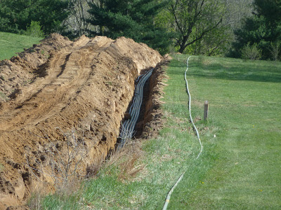
 Here is the end of the buried pipes. You can see the 2 stakes shown later that indicate the direction of the connecting piece.
 And the PE pipe to bring the flare gases and vapors to Witt Farm.
 I hope they will not do too bad of a clearcut to put the pipes through the woods - and I am really curious how they will put the pipes under the creek.

Wednesday, May 8, 2013

Pipeline Connected to Well Head in Heritage Park, Pipes all Under Ground Until Floodplain

The pipeline is now connected to the well head.


And all buried 4 feet under ground.


The pipes lying ready to be buried down at the floodplain are now also welded to the pipes coming down from the wells. Ground water level is still very high. Do they need to wait until the ground water retreats to bury the pipeline into the flood plain?


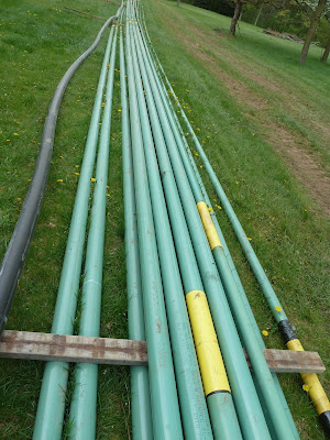
The long diagonal until the forest line shows a stack of 15 pipes. The 10 lower level pipes are most probable the ones to continue through the woods to Beaver Creek, and go under the creek bed - maybe even up the bluff to connect to the end of the buried pipes on the uplevel fields.

 This picture reveals the purpose of the black PE pipe. This is a gas pipe to transport the flare gases and vapors to the Witt Farm flare that will at least double by this. A shame that Savoy still does not collect, store and market these gases - but instead burns them off producing poisonous and cancerous gases and vapors.

Tuesday, May 7, 2013

Pipeline Goes Underground in Heritage Park

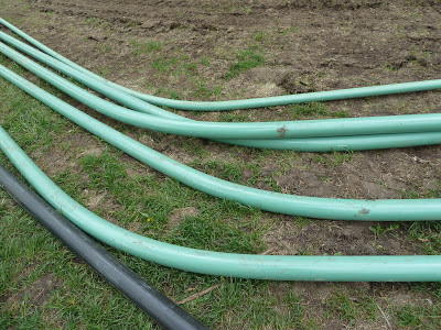
The pipes that will be buried into the flood plain are still above ground. Note the almost 90° angle from the straight down direction from the drill site towards Beaver Creek. This shows that the originally staked track will be simplified by going diagonal through part of the disc golf lawn and then cut straight through to the already laid straight track on the farm sites above the floodplain.


The five metal pipes buried 4 ft crossing the field road to the disc golf area.  Please note the still high level of ground water under the pipes.
The connection to the flood plain pipes still needs to be made.
 Ground water level is still very high. The pipes would sit in water if lowered into the trench.
 Closeup to where the pipes cross the disc golf service road. You can clearly see the 5 metal pipes and a sixth plastic pipe (what for?)
 Strange attachments on pipes waiting to be buried. Are these floating devices - but what about the wires?
Asphalt gravel is distributed and is spread out over the road crossing using a caterpillar.


On the North side of the service road towards the Heritage drilling site, the pipes leave the 4 ft. trench and have to be carefully lifted into trench  step by step.


On the way back from our walk (40 minutes later), 5 metal pipes are inside of the trench facing the floodplain. A sixth metal pipe is still outside. In some areas the pipes look very zig-zaggy - not very trustworthy...

But still have to be laid underground one-by-one for another 50 yards towards the Heritage Park drilling site.

At the same pace the excavator progresses some 100 yards ahead towards the drill site.


Michigan Significant Pipeline Incidents Listing


http://primis.phmsa.dot.gov/comm/reports/safety/IncDetSt_st_MI_flt_sig.html?nocache=2672#_all

Showing quite a high incident of material, welding, equipment failure (MAT'L/WELD/EQUIP FAILURE) - and these are leaks that were detected. Leaks in the small diameter pipes going 3 feet deep into the soil between Heritage Park and the Witt Farm (approx. 1 mile long!!) will not be easily detected. Standard checkups for some of the pipe segments will not be done before 6 years - and not for the entire length...