Saturday, August 3, 2013

Savoy's Oil Production in our Area

I tried to pull the public data on well production on the DEQ website at http://www.michigan.gov/deq/0,1607,7-135-3311_4111_4231-98518--,00.html but it is not as easy as you would think. Data are stored as PRU (Production Reporting Unit) and have to be aligned to the well permit number, which could be easier, and is not always a 1:1 relationship, meaning a PRU can include several wells - and there is no convenient way to export the more than 2 months old data from the Online Data Base at http://ww2.deq.state.mi.us/mir/ so I had to write the numbers down. There is also a Microsoft Access data base that you can download but it is even more behind (lacks data for April and March 2013!). I finally managed to get these numbers:

First, Savoy is the 3rd largest exploiter of crude oil in Michigan at a 2013 total of 236606 barrels. The largest player is West Bay Explorations, which exploit the oil fields in the Irish Hills at 811494 barrels in 2013. Number 2 is Merit Energy at 457779 barrels. These numbers are from March 2013 though!

The below table is a small selection of the total oil production in our area. I just pulled the two wells closest to the City of Adrian and two wells more NW in Adrian township, and SE in Palmyra township. However, some wells in these areas are producing more, others less than the figures shown. The two selected locations are in no way representative for their areas.


Date Production in barrels

Heritage Park Witt Farm 60488 in Palmyra 60558 Pentecost Hwy
Feb-13 - 1697 150 2773
Mar-13 - 5628 108 4602
Apr-13 160 6162 101 3789
May-13 620 6050 91 3391


The oil companies have 45 days from the end of a month to report (yes, you heard right - they monitor how much they make themselves - there is no calibrated device that measures production) - then the overworked and understaffed DEQ has to compile and update the database - resulting in a time lag of currently more than 2 months. Therefore we do not have data on any newer wells yet - or more recent changes in production of present wells. Therefore there are no data yet on the wells on the Purse Funeral Home, Stratton's Landscaping, or the 1-3 wells off Carson Highway.


Thursday, August 1, 2013

Witt Farm Prepared to process up to 6 Wells - Flare is very Large and Smelly

Since a few days the wind carries very strong fumes from the hidden flare on Witt Farm all the way to Heritage Park. The smell reminds me of sulfur and hydrochloric acid, which could be connected to the intense drilling and brine pumping we see since a while on the Purse, Stratton and Heritage Park wells. I took a look from the farm entrance but had only my cell phone so the pictures are not very good. But will be updated now:


 The flickering of the air above the barrel from the strong flare inside is not really visible but you can see that there are now 6 storage barrels, which corresponds to 6 wells being processed now or soon to come 


Look at the sizzling air above the barrel. This will give you an indication of how much stuff is emitted into the air all the time.

There are now also six separators for up to six wells


Saturday, July 27, 2013

New Drilling Sites in Adrian

First the North East. There are two permitted well on Sutton's Landscaping, two new permitted wells with horizontal drilling on two farms off Valley Rd (60770 and 60771). Nobody saw the drilling rigs - they were probably not visible from the road - or are permitted (already a month ago) but not yet drilled. Both locations are very close to the Cook Drain that flows into the South Branch of  the River Raisin.
There is also a re-entry permit on Stratton's Landscaping (60775) - with a rig visible since a few weeks.
The rig that was off Carson and  Williamsburg Drive drilled twice horizontally (60757 and 60784). On the same old farm (Frye), there are two more bottom holes, each with a permitted horizontal drill (60785 and 60786), which also nobody saw. Again the rig must have been hidden behind trees - or the permit is not yet fulfilled - probably the latter as the well permits are not published yet on DEQ Weekly Oil & Gas Permit List. Interesting is that permit 60786 ends under Lake Drive next to Lake Adrian, one of the city's major drinking water sources.


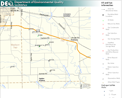
In the Southeast, there is a new re-entry permit on a producing oil well (60774), and two new permits (60756 and 60758) NE of Ogden Station.


There is also movement in the West (where the other half of Adrian's drinking water comes from). It is concentrated around M34 with many older wells, most of them dry and some producing since a long time. There is one new permit for a horizontal well at the end of Douglas Drive close to two ponds and the Porter Drain (60764).


Friday, July 26, 2013

The Extend of Oil and Gas Drilling arround Adrian

We seem to be lucky here until now. Other regions were hit much harder with oil and gas wells next to each other all over the place...


The Extend of Oil and Gas Drilling in Michigan

Unbelievable - if you project all oil and gas well records (including dry holes) onto a map of Michigan - almost no place in the lower peninsula is really 100% untouched, clean, and pristine. Where is PURE MICHIGAN?


Tuesday, July 23, 2013

Look what's Back at Heritage Park

Pump stopped working. Guess there is not enough pressure to push the oil through the pipeline to Witt Farm.